District 2 , District 3 , District 4
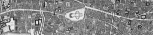
I thought it a little more interesting by following the enumerator along his or her steps as they listed the census for an area. Chosen is the District 7 of South Hackney in 1871. This is particularly to be able to list the relevant public houses, beer houses and taverns in Hackney; but more importantly to put the area of Hackney into perspective.
This is ongoing, and also helps to ensure all Public Houses are listed correctly, and ensure that road numbering changes that appear to confuse allow a better perspective of an area.
I think the enumerators description of this area is a good start - this relates to 111 census pages. I list a few of the entries along the way ........
"That part of the District which comprises the East side of Mare Street from King Edwards Road. The south side of Well Street round to King Edwards Road as far as St Thomas Road. Including Tryons Place and Court Coach Yard, Tudor Grove, Shore Road, St Thomas Road, Percy Road, Manor Road and Church Road."
Mare Street - numbers from 76 [not always consecutive] to 150
88 Smith - Thomas Lambard
98 Coffee House Keeper - William Perry
114 Greengrocer - Benj Sawyer
Well Street - numbers 1 to 10
1 Grocer - Robert Price
Denmark Place, Well Street - numbers 1 to 10
5 Carpenter - Thomas Waller
9 Telegraph Clerk - Thomas Sayer
Percy House, Eton Villas, Cromwell House, Norfolk House, The Pagles, Woburn Villas
Percy Villas, Percy Place, College Terrace
Hackney Theological College
Well Street - numbers downwards from 21 to 10
Percy Place
Northumberland Arms, Well Street - Thos K Hall
[END OF THIS ENUMERATORS STEPS]